Image credit: UPEI School of Climate Change and Adaptation Drone Team, Savage Harbour, PEI, D. E. Jardine.
Introduction
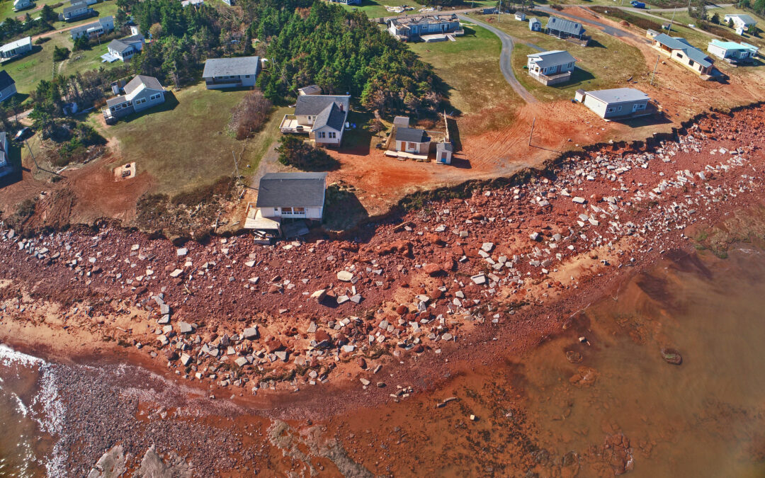
Just over a year ago, Hurricane Fiona caused significant damage across Atlantic Canada (Mulligan, 2022; Santa Maria, 2022). Since then, a number of reports and analyses examining the aftermath were published, including a report in June 2023 on highwater marks and shoreline erosion on Prince Edward Island (PEI).
Post Tropical Storm Fiona Highwater Mark and Shoreline Erosion Field Notes with Photos (“Fiona Field Notes”) is an account of the damage Fiona caused at 56 locations along the PEI coast. Don Jardine, the report’s author, examined and measured the impacts by interviewing local residents at each site and collecting instrumented data. Highwater mark, tide gauge and weather station data, and maps and graphs illustrating the impacts are provided. The intent is to help property owners, associations, professionals, municipalities, and provincial governments (Jardine, 2023, p. 1) better plan and prepare for future storms.
Specifically, the report presents information to assist with:
- identifying areas of risk;
- predicting floods;
- documenting coastal vulnerability; and
- informing flood inundation maps for low-lying areas that experience storm surge (Jardine, 2023 p. 1).

Image credit: Planet Satellite Photo Ebbsfleet, D.E. Jardine.
The power of data and citizen knowledge
Storms and hurricanes are not new to Atlantic Canada. Over time, residents, communities, organizations, and governments have enhanced their understanding of risks, increased the complexity of responses, and developed new ways to recover from extreme events together. As climate change repeatedly brings increasing impacts to the same areas, the limits of past adaptation actions are being reached.
Barbara Weit Road on PEI is an example of a repeatedly flooded area in need of a better adaptation approach. “In over 60 years living at this location, this is the worst flooding [residents] ever experienced during a storm surge,” Jardine wrote in Fiona Field Notes (p. 53). Storm surges are a common occurrence in this area, but in order to prevent even worse flooding, new adaptation responses are required.
The data in Fiona Field Notes also provide valuable information for validating the models and flood projection systems relied upon for emergency preparedness (in the short term) and planning (for the long term). With each new strong storm, scientists learn more about them and their impacts. For example, when trying to determine how often strong storms will occur, having long term records of storm conditions ensures future projections are more accurate.
Qualitative data of storm conditions provides additional context to validate models and maps. Two residents described this:
- “Buster did say that when the tide was supposed to be out it only dropped a foot or two which was unusual” (Jardine, p. 3); and
- “Mr. Doucette stated this was the worst storm he had ever experienced with the wind “screaming” at a pitch he had never heard before” (p. 79).
Buster described the drop (or lack there-of) in tide as “unusual” (p. 3), implying low tide was higher than expected, compared to previous storms. This speaks to Fiona’s intensity, by the water level being higher than usual from storm surge and low atmospheric pressure – despite an offshore wind. As a record-setting storm, Fiona tested the region’s ability to prepare for a storm whose magnitude has not been experienced before. The ability to use the observations and instrumented data to better inform emergency preparedness and flood projection systems could potentially help with planning for the next record-setting storm.
Mr. Doucette’s testimony about wind and its pitch indicates the rarity of these winds on the Island. His testimony also stands out from other citizen insights which are mostly associated with water. The extent and scale of widespread loss of trees and damage to infrastructure across inland areas were not common in past storms. Adaptation measures for high winds should also be considered and explored for future storms.
The data, flood maps, and aerial images shown in Fiona Field Notes help residents in PEI and across Atlantic Canada understand which areas are vulnerable in similar events. With that information, they can prepare for future storms, minimize potential damage, and recover from the unavoidable damage. It is important to note that not everyone will experience storm events in the same way. There are inequities in the ability and capacity of each resident, household, or community to prepare and respond. Future planning must take this into account.
Conclusion
As storms and hurricanes are expected to become more intense and cause more damage under a changing climate (Mulligan, 2022; Colbert, 2022), new ways to prepare and respond will be needed. This approach presents preparedness as multi-faceted, incorporating different aspects by combining data collected by scientific equipment with the testimony of residents. This strengthens the capacity to identify areas of risk, predict floods, document coastal vulnerability, and inform maps (Jardine, p. 1), allowing residents and communities to prioritize responses. It also breaks down the silos of action in favour of spurring collective and interdisciplinary action, which will be necessary to avoid the testimonies collected after Fiona from becoming more commonplace into the future.
Recent Comments